


Fligely’s Topographic Mapping of Walachia (1855–1859),
Szathmári’s Map of Southern Romania (1864),
its Geo-referencing and Publishing on Web (2011–2014)
Authors, affiliations
Zs. Bartos-Elekes PhD: cartographer and map historian, leader of this project; associate professor at Department of Geography in Hungarian, Babeş–Bolyai University (Cluj-Napoca, Romania).
Dr. habil. G. Timár PhD: geophysicist and geodesist, associate professor and head of department at Department of Geophysics and Space Science, Eötvös Loránd University (Budapest, Hungary)
Z. Imecs PhD: geographer and expert in geoinformatics, assistant professor at Department of Geography in Hungarian, Babeş–Bolyai University (Cluj-Napoca, Romania)
Zs. Magyari-Sáska PhD: expert in computer sciences, assistant professor at Department of Geography for extensions (Gheorgheni), Babeş–Bolyai University (Cluj-Napoca, Romania)
Contact: charta1864@cholnoky.ro
Introduction: sources, aims, methods
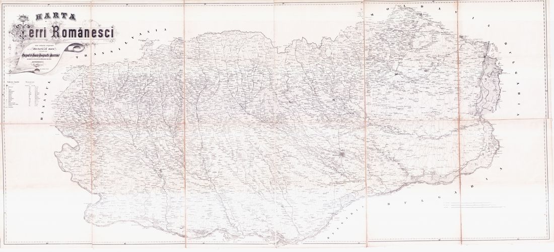
150 years ago, in 1864 a detailed map was made about Walachia, its title is Charta României Meridionale (Map of Southern Romania), it has 112 map sheets, it is often called after his draughtsman: Szathmári’s map. The map has an outstanding position in the history of Romanian cartography, because it indicates a turning-point. Before the map, foreigners (Austrians and Russians) had made topographic maps about this vassal principality of the Ottoman Empire. The Austrian topographic survey (1855–1859) – which served as a basis for this map – was the last one and the most detailed of these surveys. The map was made between the personal-union (1859) and independence (1878) of the Danubian Principalities. This map was the first (to a certain extent) own map of the forming country. As a consequence of this survey and map, the Romanian mapping institute was founded, the one which – based on this survey and map – began the topographic mapping of the country.In the Romanian scientific literature imperfect and contradictory information has been published about this map. The only a dozen copies of the map were kept in few map collections; the researchers could reach them with difficulty.
During our research we processed the circumstances of the survey and mapmaking, discovering its documentation in the archives of Vienna, as well as using the Romanian, Hungarian and German scientific literature. We found the copies in map collections from Vienna to Bucharest. We digitized all the map sheets from different collections, obtaining an 3960 megapixel image. We calculated the parameters of the used geodetic datum and map projection. We published it on web, thus we made the map reachable for everybody. The map can be viewed in different zoom levels; it can be downloaded; settlements can be found using the place name index; areas can be exported in modern projection, so the conditions of that time can be compared with today’s reality.
Historical and topographical precedents: the first Austrian maps of Walachia
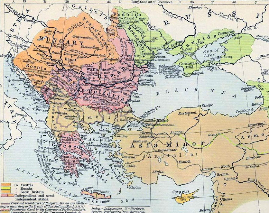
On the Balkan Peninsula in the 18th and 19th centuries the Ottoman Empire was in decline, the Habsburg Empire and the Russian Empire became stronger. Between these three powers, Walachia (now the southern part of Romania) was a vassal state of the Ottoman Empire, but sometimes it was occupied by Austrians or by Russians.Between 1718 and 1739 Lesser Walachia (the western part of Walachia, now Oltenia) was under Habsburg rule, during this time Friedrich Schwantz made a simple topographical map of it in 1722. Between 1769 and 1774 Russia occupied Walachia, Friedrich Wilhelm von Bauer (Bawr) made a map at the scale 1:288,000 for them in 1781. The first detailed topographical survey and map of Walachia was made by the Austrians during their occupation between 1788 and 1792, the map was made by Specht at a scale of 1:57,600, and it could be considered as part of the First Military Survey of the Habsburg Empire. (Docan 1912, Băcilă 1931, Buchholtzer 1937: 81–85, Popescu-Spineni 1978: 180–191, Timár 2008b)
| 
|
| Figure 1. Historical Map of the Dismemberment of the Ottoman Empire since 1683. In: Historical Atlas by William Shepherd, 1911. | Figure 2. Map of Walachia by Specht from 1791, detail. (Specht 1791, map sheet no. 75) |
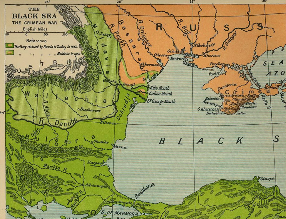
The historical background: Austrian occupation of Walachia during the Crimean War
In July 1853, Russia occupied Moldavia and Walachia, which were under Ottoman control. Therefore Turkey declared war to Russia on the 4th of October 1853. Later, many European powers supported Turkey. During this war, Austria remained neutral but contracted with Turkey in Constantinople on the 14th of June 1854, that Austria induces Russia to evacuate the two principalities (Convention of Boyadji Koy). Under the pressure of Austrians, the Russian army left Moldavia and Walachia on the 8th of August 1854, and after two weeks Austria occupied Moldavia and Walachia as a peacekeeping force. Thus, the location of the war moved to the Crimean Peninsula. Russia was defeated in January 1856. The Treaty of Paris was signed on the 30th of March 1856, therefore Russia restored riverside territories to Moldavia and Turkey, and the two principalities remained under Ottoman control. (Tarlé 1952)Thus, during (and a little bit after) the Crimean War, the Austrian army occupied the two principalities. The occupation started on the 19th–22nd of August 1854. The 30,000 Austrian soldiers were directed by Johann Baptist Coronini-Cronberg, the governor of Banat. From September of 1854 Barbu Stirbey became the Prince of Walachia. Austria left the countries in March 1857. (Scafeş–Zodian 1981: 148–161, Ionaşcu – Bărbulescu – Gheorghe 1975: 157, Boicu 1972)
|
| Figure 3. The Crimean War (Black Sea. In: Cambridge Modern History Altas. Cambridge University Press, 1912). |
The circumstances of the beginning of the survey: the contract between Austria and Walachia
|
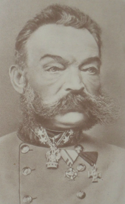
| Figure 4. The portrait of August von Fligely (1810–1879). He was born in Janów Lubelski (at that time Galicia, now Poland). Between 1854 and 1872 he was the director of MGI. He died in Vienna. |
Austria contracted with Walachia. According to the contract Walachia had to pay 120,000 Gulden (or Forint) to Austria and would get a copy of the map made by the Austrians. Once Brătianu brought up the large size amount against Stirbey, mentioning that the Austrians had got strategic data and Walachia hadn’t got any copy yet (Boicu 1972: 289–291). We have to mention that this contract is related in various ways in the Romanian literature. According to earlier authors, the Austrians surveyed the territory on behalf of Stirbey (Buchholtzer 1937: 87, Popescu-Spineni 1978: 232). According to the authors from the 1980s, Stirbey asked the first graduates of the military school of Bucharest founded in 1850, and the Austrian officers were only a technical support for them (Dragomir 1986: 131, Rotaru 1989: 34).
As a consequence of the contract the Austrian Institute of Military Geography (Militärgeographisches Institut, MGI) and its director, August von Fligely, had the task to survey Walachia (Buchholtzer 1937: 91–93, Brătianu 1900; Kovács 2010).
The surveying organization: the MGI
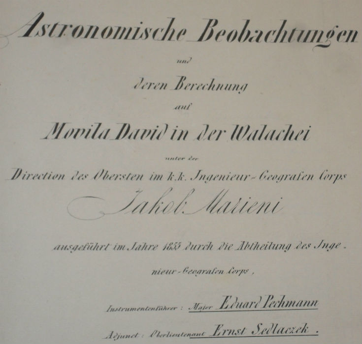
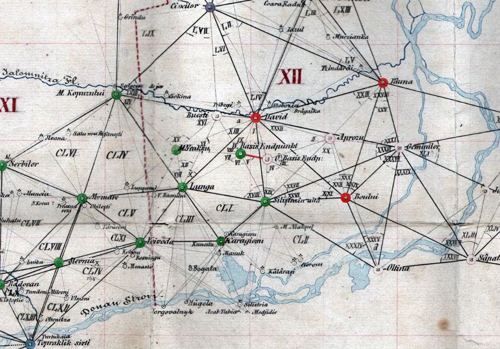
The surveying organization of Walachia was the same as for the Habsburg Empire, the MGI. In general the institute had the following tasks: astronomic and geodetic measurements, topographic survey, lithographed maps, and new editions. Seven departments made the winter work in Vienna (lithography, printing), the eighth department, the mapping one in summer made the field works. All of the original documents of the survey are kept in the War Archives of the Austrian State Archive in Vienna (ÖStA-Kriegsarchiv). (Jankó 2007: 56–59)According to these documents (Feld Manuale Wallachei) they started the works close to Slobozia: the astronomical observations at the Movila David fundamental point were completed by Major Eduard Pechmann von Maahsen, the works at the baseline were directed by Colonel Iacob Marieni.
The development of the triangulation network was carried out by majors Eduard Pechmann von Maahsen and Ignaz Edler von Rueber and captains Johann Ritter von Ganahl, Némethy, Schmidt, Schönhaber, Grüner, Hittnern and Zaufel as well as Lieutenant Breimann.
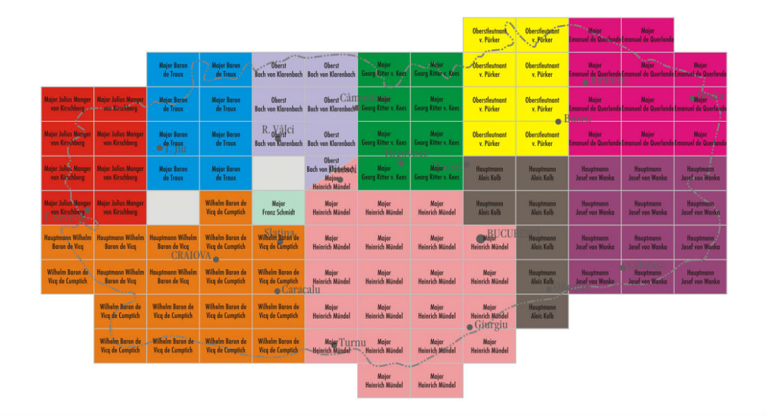
The name of the leader of the topographic work is written on the map sheets. The leaders are the following: Major Mündel (21.5 sheets), Captain de Vicq de Cumptich (19), Captain von Wanka (12), Major de Querlonde (11), Lieutenant-Colonel von Pürker (8), Major Manger von Kirschberg (8), Major Ritter von Kees (8), Major de Traux (8), Captain Kolb (7), Colonel Bach von Klarenbach (6.5), Major Schmidt (1), two map sheets are anonymous.
According to the Romanian publications, besides the Austrians, Romanian officers took part in the surveys too, among them Constantin Barozzi (1833–1921), later director of the Romanian military geographic institute and minister of defense (Buchholtzer 1937, Popescu-Spineni 1978: 232, Rotaru 1994: 3–8, Rus 2008). According to Dragomir (1986: 131) and Rotaru (1989: 34) Constantin Barozzi, Gheorghe Borănescu, Gheorghe Slăniceanu, G. Sachelarie, Emanoil Boteanu, A. Gramont, A. Angelescu and Gheorghe Mărculescu were the sub-lieutenants.
| 
|
| Figure 5. The title page of the document about the astronomical observations. | Figure 6. The names of the leaders of the works (Austrian series). [Full resolution download] |
The area and the period of the survey: Walachia, 1855–1859
During this period in the Habsburg Empire the Second Military Survey was in progress. In Transylvania they started the works in 1853, in the southern parts, bordering Walachia, in the environs of Sibiu (at that time Hermannstadt), the extreme points were Haţeg, Alba Iulia and Făgăraş. The survey of Transylvania was interrupted in the same year as in Walachia, in 1857, and was continued only in 1868 (Jankó 2007: 59–62). The survey of Walachia was part of the same work as of Transylvania, so it could be considered as part of the Second Military Survey.The area of the survey was Walachia and the central parts of Dobruja, which was part of Turkey at that time (the triangulation network reached Constanţa, at that time Köstence, Turkey).
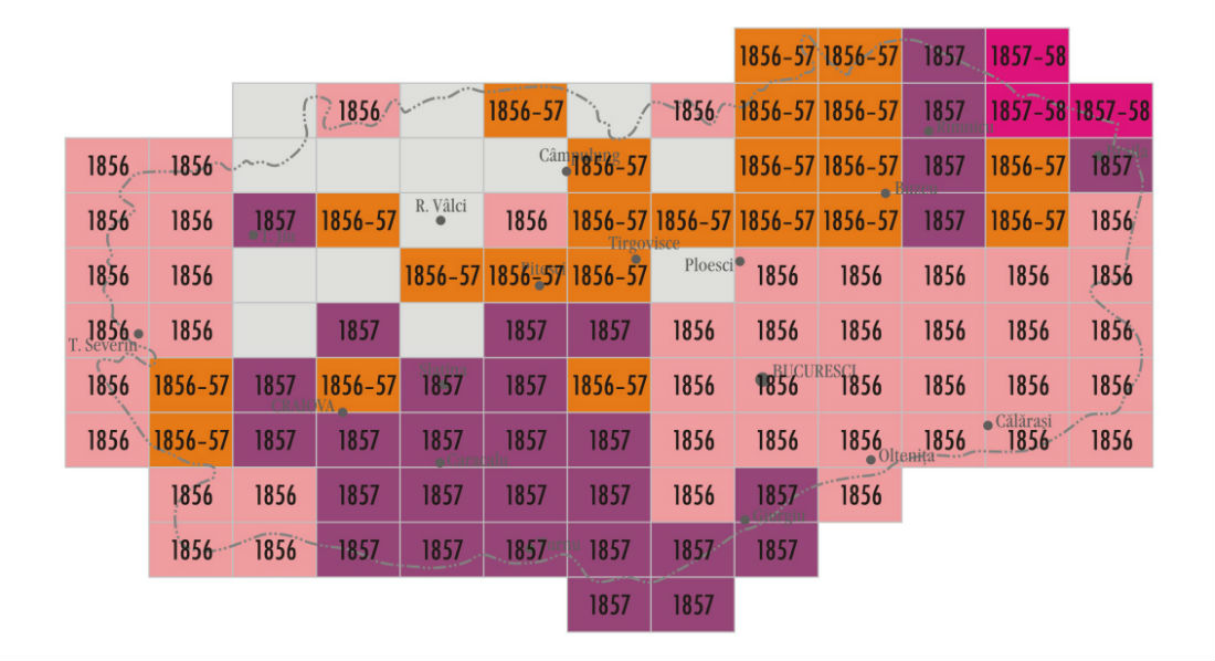
The survey started in April 1855 with astronomical positioning at Movila David, which continued until October 1855. The first measuring at the base line was on the 11th of July 1855, but three-quarters of the measurements are from 1856. The officers left Walachia in 1857. 43 map sheets are dated from 1856, 22 sheets from 1856–1857, 30 map sheets from 1857, 3 map sheets from 1857–1858, 14 map sheets are undated. The documentation was closed on the 23rd of September 1859.
|
| Figure 7. The years of the map sheets (Austrian series). [Full resolution download] |
The geodesic basis: Walbeck ellipsoid
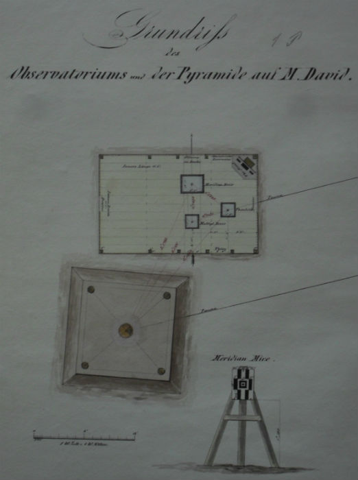
The Second Survey in Habsburg Empire was based on the earlier measurements (Jankó 2007: 62–63), but in Walachia this survey had the first geodetic measurements. The fundamental point was at Movila David (west to Ciulniţa at Lat=44.53663358, Lon=27.33086233 on WGS84), where they built a temporary astronomical observatory and made astronomical measurements, they had an azimuth fixed to Movila Păunei (east to Platoneşti at Lat=44.60336108, Lon=27.73378514 on WGS84).A 6648 m length baseline was set up slightly south of the fundamental point, situated north to Dragalina (western endpoint at Lat=44.456611 and Lon=27.28108603, center point at Lat=44.44941256 and Lon=27.32357508, eastern endpoint at Lat=44.44282397, Lon=27.36235811 on WGS84).
| 
|
| Figure 8. The ground-plan of the observatory. | Figure 9. The profile of the western point of the baseline. [Full resolution download] |
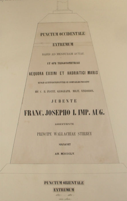
Fligely had the task to measure the difference between the sea-levels of the Black and Adriatic Sea. For this season the eastern end of the triangulation network was at Constanţa. In 1855 the network reached along the Ialomiţa river the frontier on the Transylvanian Alps, connected it to the Hermannstadt observatory on Vízaknai-hegy, (now Dealul Sibiului, close to Sibiu), fundamental point in Transylvania. In 1856 they continued the work along the Danube, thus the network was connected to Eastern Hungarian network parts, to the Szentanna (now Sântana, close to Arad) baseline. (Buchholtzer 1937: 91–93, Brătianu 1900, Kovács 2010).
According to the original documents (MGI 1859), for the survey of Walachia, the Walbeck 1821 ellipsoid was used (a=6376896 m, b=6355835 m, 1/f=302.78). Otherwise the survey was the continuing of the survey of Transylvania, where the Zach–Oriani ellipsoid was used (a=6376130 m, b=6355562 m). The prime meridian was Ferro, the difference between Ferro and Greenwich is 17.66317844 degrees (Timár 2007, Timár 2008b). At the height measurements the Austrians didn’t register any difference between the two sea-levels (Brătianu 1901: 6–7).
| 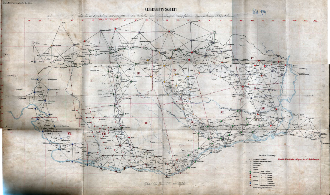
|
| Figure 10a. Detail from the map of the triangulation network. | Figure 10b. Whole triangulation network. [Full resolution download] |
The projection of the map: Cassini–Soldner
During the Second Military Survey of the Habsburg Empire the MGI used the Cassini-Soldner-projection with different centers for different lands (Timár 2004, Jankó 2007: 64–66). For the survey of Walachia they used as center the same point as for Transylvania: Dealul Sibiului (Lat=45.84028617; Lon=24.10833475 on WGS84) (Timár 2008a). This projection is a transverse cylindrical projection maintaining scale along the central meridian and all lines parallel to it and is neither equal area nor conformal.The scale of the map: 1 inch = 800 fathoms (1:57,600)
The usual scale of the Second Military Survey of the Habsburg Empire was 1: 28,800, but because of the short time, the scale of these map sheets were halved to 1: 57,600, so 1 inch on the map equals 800 fathoms on terrain (the used length unit were the followings: 1 Viennese mile equals 4000 fathoms, 1Viennese fathom is 1.89648 m, 1 fathom equals 72 Viennese inch).According to Buchholtzer (1937:32) and Năstase (1972), there were also 1:28,800 scaled Austrian survey sheets connected to this project, but in the Vienna archive we haven’t found any sign or trace of them. We suppose that the source of the misunderstanding in the Romanian literature is that the labeling system of the Austrian sheets is the same as for the sheets of 1:28,800.
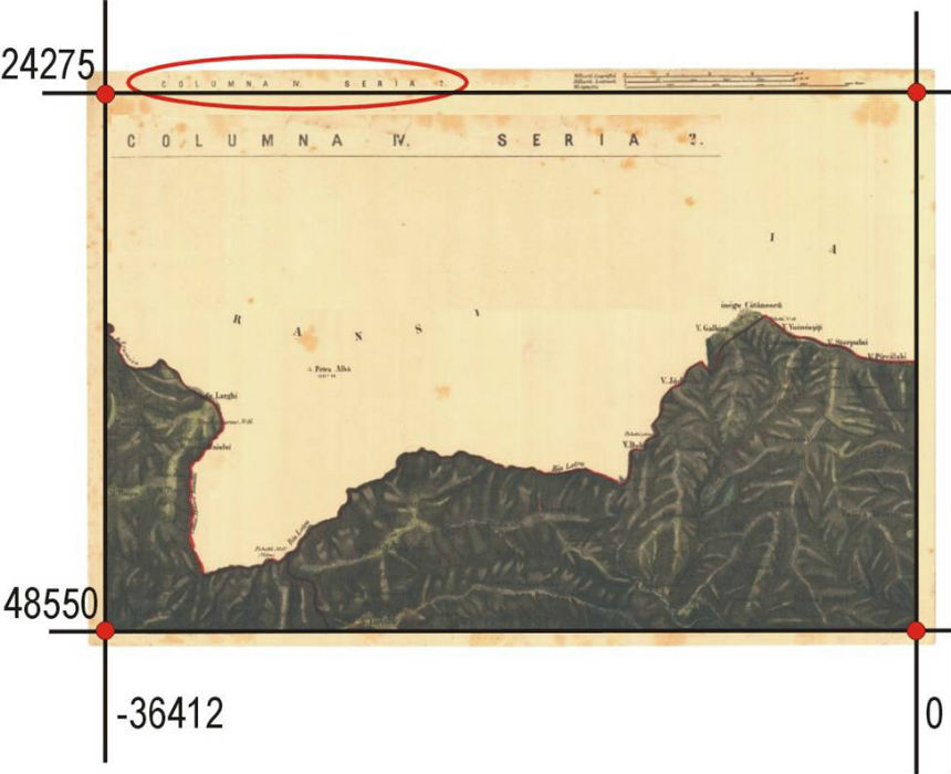
The map sheets: 16 * 24 inch (3.2 * 4.8 mile)
During the Second Military Survey in the Empire the MGI used two kinds of dimensions for map sheets (Jankó 2007: 59–62). Although after 1820 they used mainly the newer, quadrate one – here they used the older ones, like in Transylvania and in Hungary, too. One map sheet represents 12,800 fathoms * 19,200 fathoms (24,274.99 m * 36,412.49 m) on the terrain and has a dimension of 16 inch * 24 inch (42.14 cm x 63.22 cm) on the sheet.The Austrian manuscript map series: 112 sheets
The topographic map sheets based on the survey were a secret, colored, manuscript maps. One or two copies were compiled in Vienna (Jankó 2007: 68–75). The original map sheets are kept in Vienna. Maybe there was a second copy, too, if it still exists, it could be in Bucharest.The map contains 112 sheets at the scale of 1:57,600. The series has no title, no legend, no index map sheet. Sheet labeling was given in two versions.
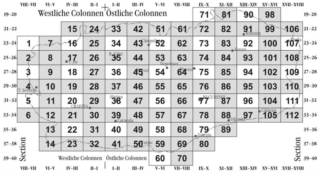
One version is the older one, (used during the First Military Survey), which used a single number (Arabic numeral) for every sheet, starting from the northwestern corner, numbers increasing from north to south, and then continuing to the northern end of the next sheet column to east. These labels are only hand-written on the map sheets, they were used later on the index map of the reduced map, too.
The other version is similar to the systems used for the lands of the Empire during the Second Military Survey. Because the sheets representing Walachia had a twice smaller scale, these sheets represent 2 * 2 normal map sheets. The origin of the numbering is Dealul Sibiului. The columns (Colonne) were labeled with Roman numbers increasing from this line, both to east and west. The most western column was the VIII–VII, the most eastern one was the XVII–XVIII. The rows (Section) were labeled with Arabic numbers, increasing from north to south. The most northern row was the 19–20, the most southern one was the 39–40 (thus the numbering was the continuation of the Transylvanian numbering).
Outside the map frame there were written the administration unit (Walachia and the name of the county), the labeling (double-row, double-column), the scale, statistics (the number of the houses, of people, of stables and of horses in each settlement) and production details (leader, year).
| 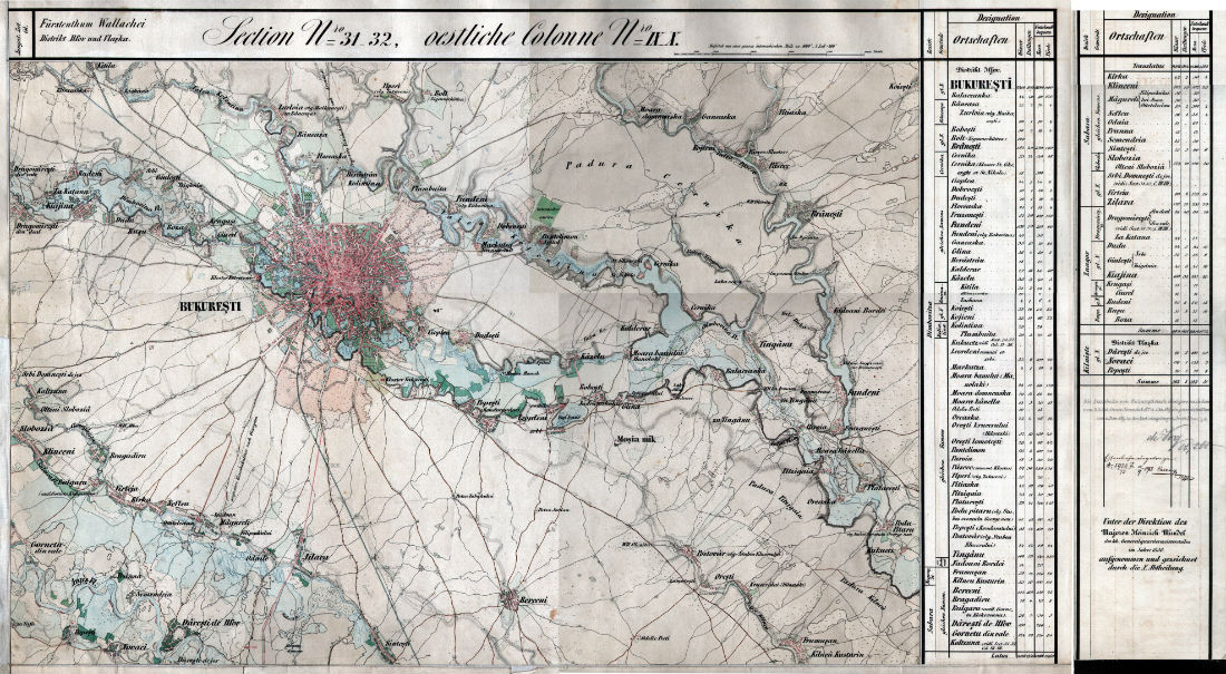
|
| Figure 11. The labeling systems of the Austrian map series. [Full resolution download] | Figure 12. The Austrian sheet of Bucharest. [Full resolution download] |
The Draughtsman’s contract: Szathmári, Vienna and Bucharest, 1860–1864
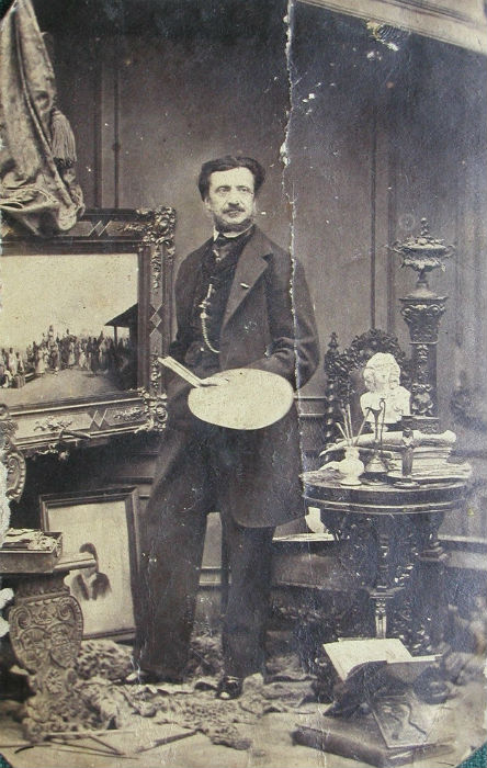
|
| Figure 13. Szathmári in his atelier in Bucharest, self-portrait (photo), 1860s. |
Szathmári was born in Cluj-Napoca (at that time Kolozsvár, Transylvania) in a Hungarian noble family in 1812. He studied at Cluj, first at the Calvinist College, later at the Academy of Law; after these he studied painting at the Academy of Vienna. He had a journey in Italia. In his Transylvanian years he published albums (portraits of the members of Transylvanian parliament, landscapes of Transylvania, portrait of Franz/Ferenc Liszt). In 1843 he was invited by ruling prince of Walachia, by Gheorghe Bibescu, to work at his court, so he moved to Bucharest in the same year. His position was later extended by Barbu Stirbey, Alexandru Ioan Cuza and the first king of Romania, Carol I Hohenzollern-Sigmaringen, as court painter and photographer. In his Bucharest years he painted the portraits of the rulers, landscapes of Balkan, the first arms of Walachia. He was war correspondent and press photographer in the wars of 1854–1855 and 1877–1878. He had several journeys in the Orient (Turkey, Persia, Russia, China). He died in 1887 in Bucharest, he was buried there, in the Lutheran Cemetery (Oprescu 1941, Oprescu 1954, Murádin 2003).
In the spring of 1860 Szathmári spent a month to study in Vienna and another month in Paris, later he purchased tools in Paris and London (Murádin 2003). We know a letter by him to his sister, Róza, dated on the 10th of June in London, in which he wrote that he had to make 1000 copies for 10,000 Guldens (Murádin 2003: 77–78). He copied the contents of the Austrian map with contact paper on another paper, where he translated the lettering to Romanian. Szathmári’s map is not a manuscript map as the original Austrian one, but a color lithographed map duplicated in some copies.
The map was printed in 1864. According to Murádin (2003: 78), the sheets were printed in Bucharest, in the joint press of Szathmári and Károly Wallenstein, while according to Romanian sources (Buchholtzer 1937: 89–90, Popescu-Spineni 1978: 232, Bogdan 2010) it was printed in Vienna. In reality it was printed in Vienna and in Bucharest as well. On some sheets, the name of the Viennese lithographing manufacture Würbel is given, so Szathmári’s map sheets were duplicated there in about 10 copies. Apart from the 112 map sheets, Szathmári’s map was completed with title, legend and index map. These three sheets were made in Szathmári and Wallenstein’s press in Bucharest (on the title his name is written in Romanian, “Satmari”; on the index map his name is written in Hungarian, “Szathmáry”).
In 1864 Szathmári – as a member of the delegation of Alexandru Ioan Cuza – gave the Romanian version of the map to the Sultan in Constantinople (now Istanbul), who gave him a tobacco box with brills and the Order of Medjedieh (Murádin 2003: 77).
|
| Figure 14. The Austrian original map (red) and the copy of Szathmári (blue). The main difference is the lettering. [Full resolution download] |
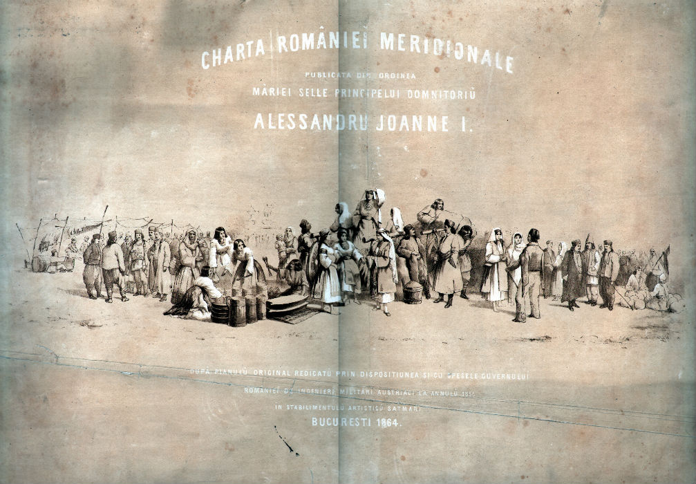
Szathmári’s map: title, legend and index map
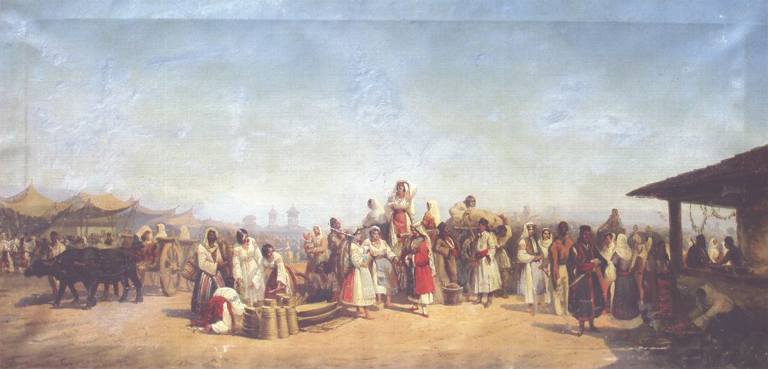
The Romanian version contains totally 115 sheets. The 112 map sheets were completed with title sheet, legend (explanation of symbols) and index map.The main title of the Romanian version, provided by Szathmári, is Charta României Meridionale (Map of Southern Romania), this is the first map on which the name “Romania” appears. The whole title is the following (in Romanian): CHARTA ROMÂNIEĬ MERIDIONALE / PUBLICATA DIN ORDINEA / MĂRIEI SELLE PRINCIPELUI DOMNITORIŬ / ALESSANDRU JOANNE I. / DUPĂ PLANULŬ ORIGINAL REDICATŬ PRIN DISPOSITIUNEA SI CU SPESELE GUVERNULUĬ / ROMÂNIEĬ DE INGINERĬ MILITARI AUSTRIACI LA ANNULŬ 1856 / ÎN STABILIMENTULŬ ARTISTICŬ SATMARI / BUCURESTI 1864. . The title translated to English is the following: Map of Southern Romania published at the order of His Majesty Prince Alexander John I., based on the original map surveyed with the disposition and expenses of the Romanian government by Austrian military engineers in the year 1856, in Satmari’s artistic institute, Bucharest 1864. We have to mention that really the maps were compiled between 1855 and 1858, and part of the printing was made in Vienna. In the background of the text there is a drawing of Szathmári about the Târgul Moşilor (“fair of ancestors” at Pentecost in Obor, Bucharest). The dimension of the title sheet is: 62 cm * 43 cm.
| 
|
| Figure 15. Szathmári’s title sheet. [Full resolution download] | Figure 16. Szathmári: Fair of Ancestors (1861). Oil painting on canvas, Museum of Bucharest at Suţu Palace. [Full resolution download] |
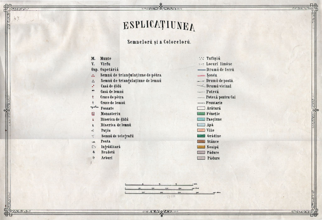
The legend is in Romanian. At the bottom of the page there are three graphical scales: Viennese mile, Viennese fathom and meter. The dimension of the legend sheet is: 62 cm * 43 cm.
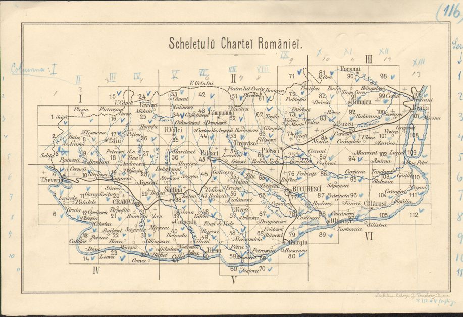
The index map sheet show the simplified labeling system: the columns are indicated by Roman numbers from west to east (I–XIII) and the rows by Arabic numbers, from north to south (1–11). The dimension of the index map sheet is: 54 cm * 36 cm.
| 
|
| Figure 17. Szathmári’s legend sheet. [Full resolution download] | Figure 18. Szathmári’s index map sheet, the Austrian labeling is written with red by hand on it [Full resolution download] |
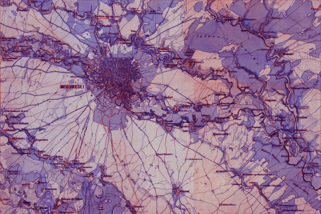
The map sheets are slightly different from the original Austrian ones. The most striking difference is that here is less information outside the frame, here the statistical data of the Austrian sheets are missing. Outside the frame only the simplified labeling is written, and the novelty is the three graphical scales. The main difference in the content is that here the lettering is in Romanian. There are some insignificant differences in symbols. The dimension of the map sheets are: 67 cm * 46 cm.
|
| Figure 19. Szathmári’s sheet of Bucharest. [Full resolution download] |
The content of the map: explanation of symbols
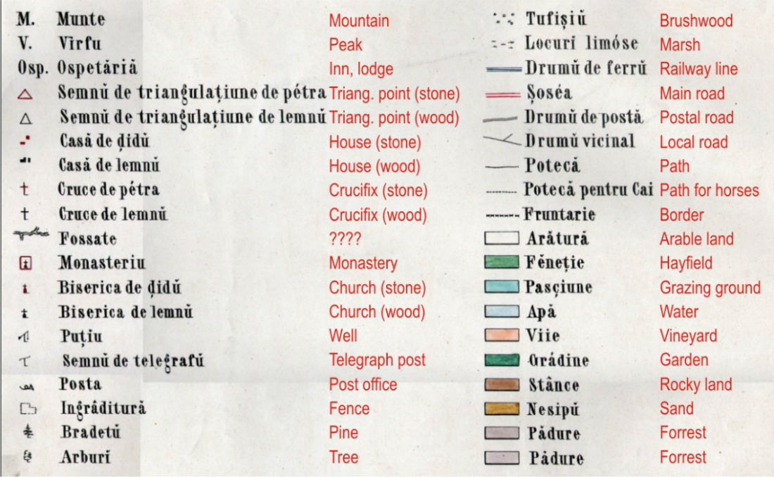
From 1827 the MGI used consistent symbols, totally 245 classes (Jankó 2007: 66–67). The legend of Szathmári’s map enumerates 38 symbols, but more symbols are used.The representation of relief is with Lehmann-hachures, the heights are in Viennese fathoms. The maps represent in detail the hydrography in blue (lake, river, marsh and well). There are several categories representing the vegetation: arable land, hayfield, grazing ground, vineyard, gardens, rocky land, sand, forest, brushwood, pine and other trees. The categories of the routes are the followings: main, postal and local roads, path and path for horses. Although at the time of printing the map the first railway line was being planned in Walachia, there is a symbol for the railway lines, too. The map represents the national and county borders. At the settlements there are distinguished the houses, churches and crucifixes of stone and wood, the monasteries, inns, post offices and telegraph posts and fences. The map shows the locations of triangulation points (made of stone or wood).
On the Austrian sheets the original Romanian toponyms in Cyrillic characters were transcripted to Latin ones, the other texts were in German. On Szatmári’s version the Romanian toponyms are in the recently introduced Latin script, any other texts are in Romanian.
|
| Figure 20. Explanation of symbols, translated to English. |
The reduced maps: Austrian and Romanian version at 1:288,000
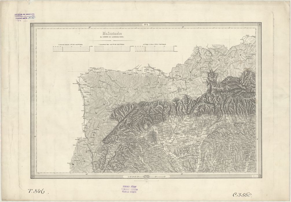
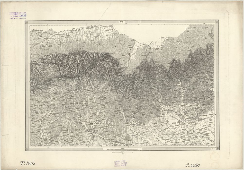
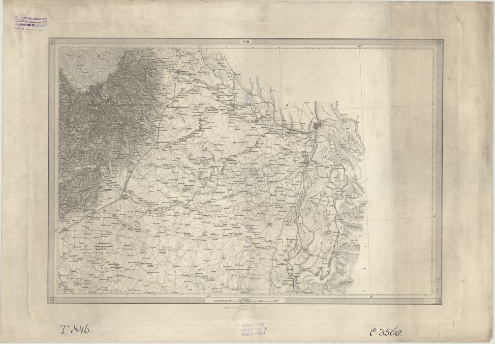
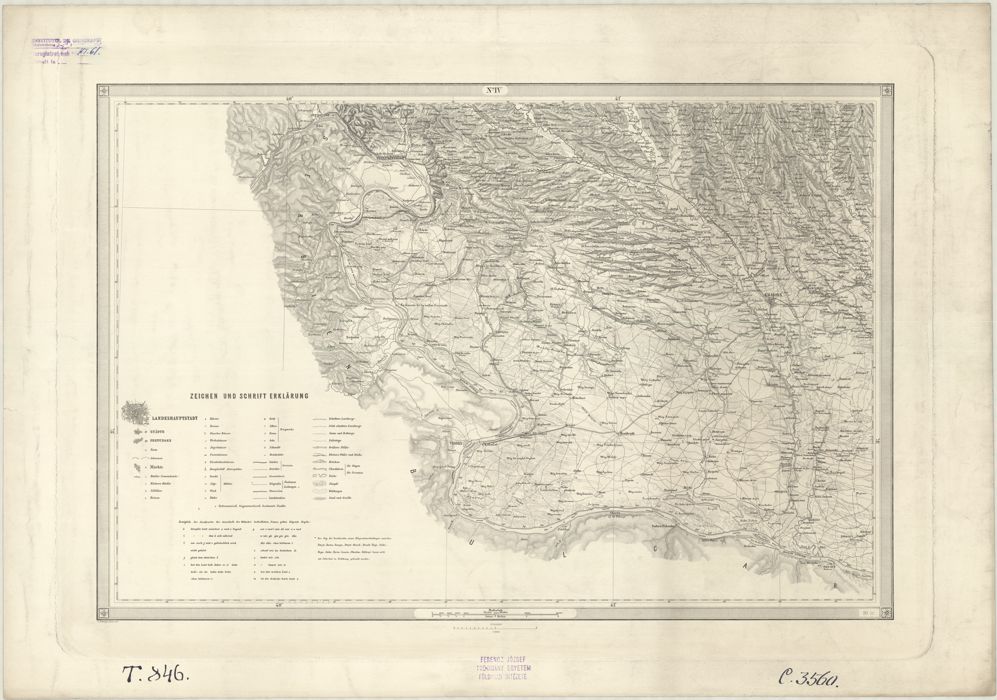
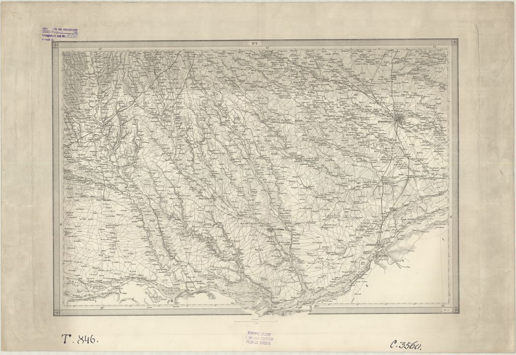
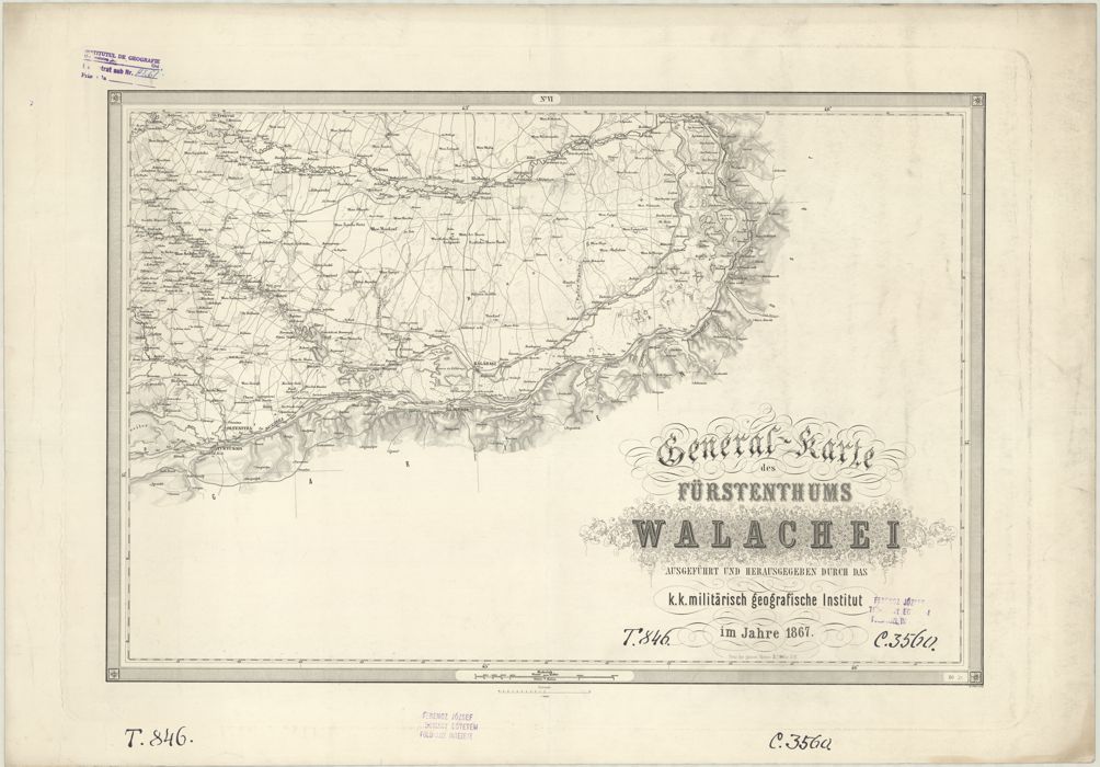
Usually at the Second Military Survey a general map (Generalkarte) at a scale of 1:288,000 (1 inch is equal with 4000 fathoms) was compiled for every land (Jankó 2007: 75–83).In the case of Walachia, the title of the Austrian version is the following: General-karte des Fürstenthums Walachei ausgeführt und herausgegeben durch das k.k. militärisch geografische Institut im jahre 1867 (General map of Principality of Walachia compiled and issued by the Imperial and Royal Military Geographical Institute in the year of 1867). It has 6 map sheets, each sheet has a dimension of 83 cm x 58 cm. It was compiled in 1867 in MGI. The place of publication is not mentioned, but it was Vienna. The names of the drawers aren’t written either. On the copy known by us the railway lines were drawn by hand later with their situation in 1878.
| 
| 
|
| [Full resolution download]
| [Full resolution download]
| [Full resolution download]
|
| 
| 
|
| [Full resolution download]
| [Full resolution download]
| [Full resolution download]
|
| Figure 21. The map sheets of the Austrian reduced map. | ||
This series had an index map, too. This little index map shows the labeling of the Austrian reduced map and the older labeling of the original survey map (and the railway lines in 1878). Its dimension is 24 cm * 17 cm.
There was a Romanian edition in this scale, too. The title is the following: Harta Ţerri Romănescĭ dupe reducţia originalâ din harta ce’ mare ridicate de Corpul de Geniu Geografic Austriac cu numirile correctate prin Ministerul din Intru (Map of Walachia after the original reduction from the large map surveyed by the Austrian Corps of Geographic Engineers with the corrected names by the Ministry of the Interior). The map is only one sheet, the dimension is 194 cm x 89 cm. The place of issue is Bucharest, but as lithography the Bielz is mentioned, which was in Sibiu (at that time Hermannstadt / Nagyszeben, Transylvania). The author and the year of publication are not mentioned. We know it in two versions. On one the year 1861 is written. On the other there is no year, but the railways are missing, so it could be before 1869.
| 
|
| Figure 22. The index map of the Austrian reduced map. | Figure 23. The Romanian reduced map. [Full resolution download] |
The consequences of the survey and maps: the Corps of Engineers
In 1859 Moldavia and Walachia unified, shortly adopted the name of Romania, and in 1878 Turkey recognized its independence.In the year when the Austrians left the area, in 1858, the Corps of Engineers (Biroul de Jeni, Corp de Geniu) was established. Their tasks were the preservation of the triangulation points and the continuing of the survey. Its members were: V. Costaforu, Gh. Slăniceanu, C. Barozzi, G. Mărculescu, N. Dona, Gh. Borănescu and E. Boteanu. Barozzi took part at a further education in Vienna, in 1860 (Rotaru 1994: 3–8).
The geodetic network of the Austrians served as a basis for the later surveys of Walachia. The survey of Dobruja was based on the line Defcea–Săpata measured by Austrians. Even in 1902 the map sheets of Walachia at the scale of 1:100,000 were based on Austrian survey (Brătianu 1901).
In this way was formed the Romanian military mapping, which succeeded the large scale topographic maps made by the foreign topographers. (Băcilă 1931, Buchholtzer 1937: 89–90, Năstase 1972, Popescu-Spineni 1978: 232)
The preservation of the maps: copies in map collections
The survey map sheets of the Second Military Survey were kept at the MGI, and after 1924 in the War Archives (Kriegsarchiv) (Jankó 2007: 83–84). There is only one series of the Austrian version there, which is complete (archive-ID: B III a 203-4). Later, the newly constructed railway lines were drawn on them (1869, 1873 and 1877). The working versions are also stored there: the whole documentation of the triangulation and survey, map drafts without lettering, lettering separately on tracing paper, proofreading. 
| 
|
| Figure 24. Draft map without lettering and only lettering on tracing paper. | |
Szathmári’s map was duplicated probably in about 8–10 copies – compare: Szathmári wrote a total of 1000 copies to his sister (Murádin 2003: 77–78). At least 1 copy was sent to Ist anbul (Murádin 2003: 77), at least 3 copies to Vienna and the rest to Romania: to army, universities and to major libraries. In 1937 Buchholtzer (1937: 87) knew about 3 copies, all in Bucharest: in the Institute of Military Geography, in the Military Museum and in the Academic Library. We have identified 8 copies so far.
In Bucharest in the Academic Library there are 2 full copies (ID: H876, C.XII.1), in Cluj-Napoca in the Cholnoky Map Collection there is one incomplete copy (88 map sheets, ID: from 51-408 till 51-494) and in Jassy at the Department of Geography of the university there is another full copy (without ID).
The joint map collection in Vienna of the Austro–Hungarian Monarchy after the WWI (in accordance with the agreement of Baden) was separated in two locations. In Vienna remained two complete series (ID: B III a 203-5 and B III a 204), one incomplete series are in Budapest in the Map Room of Institute and Museum of Military History (99 map sheets, ID: B III a 204).
It is surprising, but one copy of the full series can be found in the USA, in the Clark Library Map Collection located in Hatcher Graduate Library of the University of Michigan (Ann Arbor, MI). It was bought from the widow of Henry Vignaud in 1923. Vignaud was an American diplomat in Paris, he worked with the Romanian legation in Paris in the 1860s (ID: G2035.S91864).
Digitization: scanning the map sheets
As the project has the best connection to Cholnoky Map Collection (Cluj-Napoca) and to the Map Room of Institute and Museum of Military History (Budapest), the scanning work was made on their collections. The full series in Cluj-Napoca and in Budapest were scanned, so most of the sheets are scanned in 2 versions. All of these maps were scanned in 300 dpi lossless format in large format scanners (e.g. A/0 or 42 inch width). The remaining few sheets, as well as the damaged ones in Cluj and Budapest, were scanned in Vienna in four parts each, at the A/3 format scanner of the Hungarian delegation at the Vienna Archive, as well as some auxiliary materials and some sheets of the original Austrian version of the maps. These sheets were put together later in Adobe Photoshop. The brightness and contrast of the sheets from different sources were not modified or equalized.Geo-referencing the map: pixel, projection and datum
The geo-reference of the sheets was based on:We defined four control points for each sheet; the four corners of the map contents. Together with their image pixel coordinates, the respective projected coordinates were calculated from the map label and the terrain extents of the sheets. The projection origin has no false northing and easting, so the coordinates there are (0,0); this point was the old Dealul Sibiului observatory site, although it is outside the mapped area, far north into Transylvania. Thus the sheets were resampled to the native projection of the map, providing exactly rectangular outline for all the sheets. The mosaicking was accomplished in this coordinate system.
|
| Figure 25. The control points at the corners of the sheet. |
The Fligely-survey provided first-order basepoints and a set of secondary points, by angular measurements from the astro points. Points cover not only Walachia but also parts of the Habsburg Empire (East Hungary and Transylvania). Points were digitized and coupled with their modern counterparts in the Romanian geodetic point list. 71 point pairs were identified. The best 44 points has less than 10 meters of error, accuracy is better than 3 meters using only the best fitting 33 points.
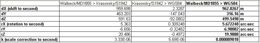
Using the coordinates of the fundamental points in both the old local datum (Walbeck ellipsoid, Movila David 1855 datum) and the modern datum (Krasovsky ellipsoid, S42/Romania datum), together with the geoid-undulation data and the nominal shift between the Ferro and Greenwich meridians, we derived the Burša–Wolf parameters of the old local datum to the modern S42 datum. This transformation between the original and the modern geodetic systems is surprisingly accurate. More than half of the original points were able to be used in a network adjustment providing less error than approx. 30 meters (1 millimeter in the map). Using the best fitting 33 original points in Walachia, the RMS (residual mean square) is only 1.426 m, the maximum error is 2.782 m. Later these parameters were added to the Burša–Wolf parameter of the S42 datum, using the (Chendeş 2011: 339). Thus, the estimated Burša-Wolf type parameters are the following: dX (shift to WGS84) =962.03 m, dY=316.16 m, dZ=499.55 m, rX=5.6722 arc-sec, rY=-6.9808 arc-sec, rZ=19.9888 arc-sec, k=9.018 ppm. We used the following parameters of Walbeck 1821 ellipsoid: a=6376896 m, b=6355835 m, 1/f=302.78. Therefore, most of the overall errors are due to the effect of the copy of the original sheets and the age, folding and drying of the paper sheets.
|
| Figure 26. The Burša–Wolf parameters. |
For geo-referencing we calculated the WGS84 coordinates at the origin of the Cassini–Soldner projection, which are the following: central meridian at 24.11456611 E, central latitude at 45.84316 N.
A further possibility to increase the accuracy and correct the above mentioned non-systematic errors, is the application of the correction grid (GSB; Grid Shift Binary, conform Molnár 2007). In this method, at selected ground control points (GCPs) the easting and northing components of the local shifts from the old and new geodetic coordinates are recorded. Based on this irregular network, a regular grid is compiled at a pre-set resolution, e.g. 10 arc minutes in both latitudes and longitudes. Densifying the GSB grid can limit the horizontal shift error to approx. 20 meters, which is below 1 millimeter in the map. A first experimental version (which is well beyond the original scope and goals of the project proposal) is about to be compiled using one GCP from each map sheet.
Publishing on Web: server and client side components
For web publishing the www.charta1864.ro domain was reserved, being a suggestive name for its content. The site contains the essay of the research as well as the interactive map for visualizing and handling the original map sheets. As a web application it has both server and client side.The physical server is a Dell PowerEdge T320 computer with Xeon four core E5-2403 processor at 1.8GHz and 4GB of RAM. The operating system is Ubuntu 12.04. As web server application the Apache Tomcat7 was selected having the possibility to execute Java Servlets. With PHP installed it’s possible to run server side programs, too. The WebGIS server application is GeoServer 2.3.4. To configure it for the production environment and to increase the processing speed the JVM (Java Virtual Machine) memory was increased and the JAI (Java Advanced Imaging) component was installed. In this way the raster processing operations were facilitated.
The client can be any computer with Internet Explorer 10, Mozilla Firefox 23, Google Chrome 30 or above. By accessing the charta1864.ro domain all the necessary files (html, css, js) are downloaded automatically on the client’s computer.
Publishing on Web: data preparation
Based on the georeferenced individual map sheets an index layer was created using GDAL. Previously it was necessary to set the projection information for all raster layers holding the map sheets. For easy handling and experimenting a small application was developed to change the projection data for all 112 sheet based on a sample file. The index SHP layer was accomplished with gdaltindex command.The same projection data had to be set also for GeoServer, in the reserved file for user projections.
|
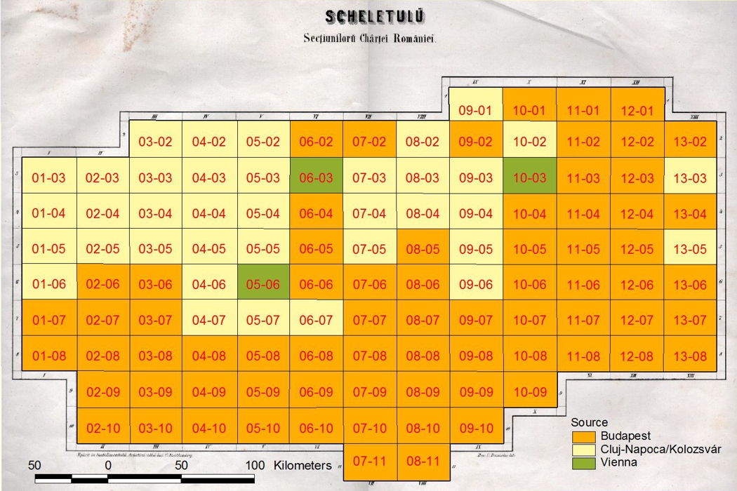
| Figure 27. Source of the maps. |
|
| Figure 28. Cached zoom levels. |
Apart from the originally developed projection data, for the rotation parameters at ToWGS settings we had to change their signs, as GeoServer considers the rotation of coordinate system instead of rotating the image.
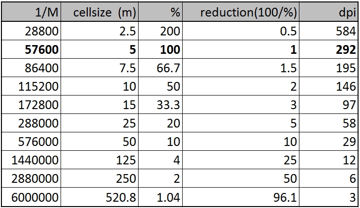
The layer created by this way can be queried using WMS (Web Map Service). Due to the fact that such a query has projection, geographical extent and image width and height as parameters, the response for it has a considerable rendering time. To counteract this shortcoming there is a way to render and cache the tiles that compose the map using the GWC (Geoserver Web Cache) Service. For this it is necessary to predefine scales for which this caching will be made. In this case 10 scale levels were defined and the tile size was 256x256 pixels.
After creating the cached tiles the GWC service gives the possibility to have short response time in map navigation.
Publishing on Web: the application
The web application consists on HTML and CSS file for frame and form and two JS files for application functions and data. The following JavaScript libraries were used: OpenLayers (for map handling), Proj4js (for projection and coordinate transformations), JQuery (for place name search). The application was created in JavaScript except the downloading of the original map sheets part, where PHP was used. To download selections from the map, a properly constructed WMS query was built based on user specifications. 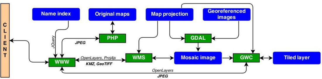
|
| Figure 29. Functional scheme of application. |
The application has the following possibilities:
1. Interactive visualization of the map, consisting in:
- zoom level selection with mouse scroll or with zoom tool, double click on map surface or drawing a rectangle over the desired region holding down the Shift key
- moving the content with mouse dragging, frame positioning in Overview map or with pan tool
The easy visual search on the map is facilitated by an overlay layer containing the Index map usable till the 5th zoom level.
2. Showing the identification data based on mouse position and current view content as follows:
- showing the row and column values for the map section on which the mouse is positioned
- showing the coordinates in the original Cassini-Soldner projection and in WGS84
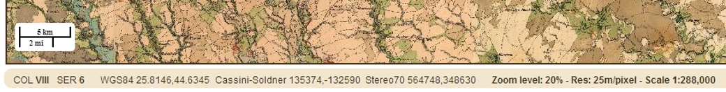
- showing the data associated with current zoom level: map scale, resolution in pixels/m and zoom level ratio
- showing the current view corner coordinates in selectable Cassini-Soldner, Stereo70 projections or in WGS84
|
| Figure 30. Identification data. |
3. Downloading and zooming to a selected original map sheet, by specifying the row and column number. The Download and Zoom to buttons become active only in case of valid numbers. The downloaded map section file name has the following format: szathmari-column-row.jpg. There is also the possibility to visualize the Title the Legend and the Index map.
|
| Figure 31. Specifying parts of map for geo-referenced download. |
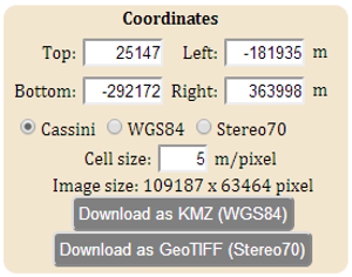
4. Downloading geo-referenced parts of the map, by
- specifying the corners of the desired rectangle. By zooming over a region the corner’s coordinates are updated automatically but the user also can manually specify these values. There is the possibility to enter them in Cassini-Soldner or Stereo70 projection or in WGS84. The corner values can also be entered with two successive right clicks, first for the top left corner, the second for bottom right corner. On changing the projection system the entered values are transformed automatically.
- specifying the resolution in pixels/m, Accepted values are whole numbers between 5 and 20, 5m representing the original resolution.
- selecting the file type, which can be KMZ in WGS84 or GeoTIFF in Stereo70
There is a limit on downloadable file extend. Neither the height nor the length of an image can be higher the 4000 pixels. The download buttons are active only if this limit is respected.
5. Searching for a settlement based on its current name. Based on the place name index containing 5182 settlement an interactive search with auto complete functionality zooms to entered location.
The place name index is based on the contemporary situation of settlements included in the area presented by the maps. As starting point we used a polygon shape file of the settlements which was transformed in the Cassini-Soldner projection. Using an overlay function in ArcGIS the settlements included in the area of the map sheets were clipped. As the polygon file has just a few attributes for the settlements, another point file was also used (its source is geo-spatial.org at earth.unibuc.ro). After clipping the points for the same territory with the help of a spatial join operation the attribute data from the points was transferred to the polygons. After checking the consistency of the data the final version of the polygon file consists of 5182 polygons. Actually this is the number of actual settlements in the area presented in the map sheets. Finally x and y coordinates of the centroid of the polygons was generated. The list of settlements has the following attributes for each settlement: name in two versions with and without specific Romanian characters; population for year 2002; SIRUTA code which is a unique code used by the National Statistical Institute; type of the settlement; the SIRUTA code and the name of the upper administrative unit which the settlement belongs to; the county which the settlements belong to and the easting and northing coordinates of the centroid of polygons.
Acknowledgments
This work was supported by a grant of the Romanian National Authority for Scientific Research, CNCS – UEFISCDI, project number PN-II-RU-TE-2011-3-0125.The authors wish to thank for the help of institutes and colleagues.
The institutes are the following: Academic Library (Bucharest), Babeş–Bolyai University (Cluj-Napoca), Cholnoky Map Collection (Cluj-Napoca), Eötvös Loránd University – Department of Cartography and Geoinformatics (Budapest), Institute and Museum of Military History (Budapest), ÖStA Kriegsarchiv (Vienna).
The colleagues’ names are the following: Constantinescu Ştefan and Păunescu Cornel (University of Bucharest); Crăciunescu Vasile (National Meteorological Organization, Bucharest); Boamfă Ionel (Cuza University of Jassy); Kovács Csaba (Babeş–Bolyai University, Cluj-Napoca); Kötő Andrea (Cluj-Napoca); Miklós Alpár (Cluj-Napoca); Murádin Jenő (Cluj-Napoca); Molnár Gábor and Szekerka József (ELTE, Budapest); Hegedűs Ábel and Jankó Annamária (IMMH, Budapest); Plihál Katalin (National Széchényi Library, Budapest); Domokos György, Hermann Róbert and Lenkefi Ferenc (ÖStA, Hungarian delegate, Vienna); Tim Utter (University of Michigan, Ann Arbor).
References
Băcilă I. (1931): Hărţi geografice asupra Ţara Românească între 1800–1856. Lucr. Inst. de Geogr. Univ. Cluj., vol IV., 1928–1929. Cluj.
Bogdan Mihai – Săvulescu Ionuţ – Demeter Traian (2010): Historical Maps (starting since the 18th century) integration in digital environment for land cover change analysis. 5th International Workshop on Digital Approaches in Cartographic Heritage. Vienna.
Boicu L. (1972): Austria şi principatele române în vremea războiului Crimeii 1853–1856. Editura Academiei RSR. Bucureşti.
Brătianu, Constantin I. (1900): Notiţe despre lucrările cari au avut scop descrierea geometrică a României. Academia Română. Bucureşti.
Brătianu, Constantin I. (1901): Note sur les opérations géodésiques et astronomiques entreprises pour l’exécution de la carte du royaume de Roumanie présentée à la XIIIe Conférence de l’Association géodésique internationale, tenue à Paris en 1900. Brill, Leide.
Buchholtzer Corneliu – Rotaru Petre (1937): Istoricul Cartografiei. Institutul Geografic Militar. Bucureşti.
Chendeş Viorel (2011): Resursele de apă din Subcarpaţii de la Curbură, evaluări geospaţiale. Editura Acedemiei Române.
Davis, Scott (2007): GIS for Web Developers. The Pragmatic Bookshelf. Texas.
Docan, N. (1912): Memoriu despre lucrările cartografice privitoare la răsboiul din 1787–1791. Extras din Analele Academiei Române. Seria II. Tom. XXXIV. Memoriile Secţiunii Istorice. Bucureşti.
Dragomir Vasile – Rotaru Marian (1986): Mărturii geodezice. Editura Militară. Bucureşti.
Hazzard, Erik (2011): OpenLayers 2.10. Packt Publishing. Birmigham.
Iacovella, Stefano – Youngblood, Brian (2013): Geoserver. Packt Publishing. Birmigham.
Ionaşcu I. – Bărbulescu P. – Gheorghe Gh. (1975): Tratatele internaţionale ale României 1354–1920. Editura Ştiinţifică şi Enciclopedică. Bucureşti.
Jankó Annamária (2007): Magyarország katonai felmérései 1763–1950. Argumentum. Budapest.
Kovács Béla – Timár Gábor (2010): The Austro–Hungarian triangulations in the Balkan Peninsula (1855–1875). In: Gärtner Georg – Ortag Felix ed.: Cartography in Central and Eastern Europe. Lecture Notes in Geoinformatics and Cartography. Springer. Berlin–Heidelberg. pp. 535–544.
MGI, Militärgeographisches Institut (1859): Trigonometrische Vermessungen in der Wallachei, ansgeführt durch Offiziere des k.k. Ingenieur-Geografen Corps, in der Jahren 1855, 1856 und 1857. Manuscripts in the ÖstA-Kriegsarchiv, Wien, Archive ID: Triangulierung/194.
Molnár Gábor – Timár Gábor (2011): Using the Grid Shift Binary (GSB) data to improve the geo-reference of the Third Military Survey of the Habsburg Empire. Geophysical Research Abstracts 13: 11861.
Murádin Jenő (2003): Szathmári Pap Károly. Kriterion. Kolozsvár.
Năstase, Anton (1972): Contribuţii la dezvoltarea cartografiei Ţării Româneşti în secolele al XVIII-lea şi al XIX-lea. Lucrări ştiinţifice. Seria Geografie. Institutul Pedagogic. Oradea.
Oprescu, George (1941): Carol Popp de Szathmary desenator. Bucureşti
Oprescu, George (1954): Szathmary. Bucureşti
Perez, Antonio Santiago (2012): OpenLayers Cookbook. Packt Publishing. Birmigham.
Plihál Katalin (2008): A térképnyomtatás művészete a kezdetektől a 19. század végéig. Hatágú síp. Budapest (CD-ROM).
Popescu-Spineni, Marin (1978): România în izvoare geografice şi cartografice. Editura ştiinţifică şi enciclopedică. Bucureşti.
Rotaru, Marian – Anculete, Gheorghe – Paraschiva, Ion (1989): Evoluţia concepţiei geodezice militare în România. DTM. Bucureşti.
Rotaru, Marian – Anculete, Gheorghe (1994): Personalităţi ale geodeziei militare româneşti. Bucureşti.
Rus, Ioan (2008): Scurt istoric al măsurătorilor terestre în România. http://earth.unibuc.ro/articole/scurt-istoric-al-masuratorilor-terestre-in-romania
Scafeş, Cornel I. – Zodian Vladimir (1981): Barbu Ştirbei. Editura Militară. Bucureşti.
Specht, Friderich (1791): Militairische Karte der Kleinen oder Oesterreichische und Grosser Wallachei. Wien.
Tarlé E. V. (1952): Războiul Crimeii. Editura de Stat pentru Literatura Ştiinţifică. Bucureşti.
Timár Gábor – Molnár Gábor – Păunescu Cornel – Pendea Florin (2004): A második és a harmadik katonai felmérés erdélyi szelvényeinek vetületi- és dátumparaméterei. Geodézia és Kartográfia 2004/5: 12–16. Budapest.
Timár Gábor (2007): A ferrói kezdőmeridián. Geodézia és Kartográfia 2007/12: 3–7. Budapest.
Timár Gábor – Kovács Béla – Bartos-Elekes Zsombor – Păunescu Cornel (2008a): The Dealul Sibiului base point of the Transylvanian surveys. Geographia Technica 2008/1: 127–139. Cluj-Napoca.
Timár Gábor (2008b): Habsburg geodetic and cartographic activities in the Old Romania. Studii şi Cercetări, Seria Geologie–Geografie. Bistriţa. 13: 93–102.
![[Full resolution download]](http://gis-it.go.ro/charta/img/06-name-of-leaders.jpg)
![[Full resolution download]](http://86.120.37.125/files/charta/img/07-years.jpg)
![[Full resolution download]](http://86.120.37.125/files/charta/img/09-profile.jpg)
![[Full resolution download]](http://86.120.37.125/files/charta/img/10all-triangulation.jpg)
![[Full resolution download]](http://86.120.37.125/files/charta/img/11-labeling-A.jpg)
![[Full resolution download]](http://86.120.37.125/files/charta/img/12-Bucharest-A.jpg)
![[Full resolution download]](http://86.120.37.125/files/charta/img/14-red-blue.jpg)
![[Full resolution download]](http://86.120.37.125/files/charta/img/15-title.jpg)
![[Full resolution download]](http://86.120.37.125/files/charta/img/16-fair-of-ancestors.jpg)
![[Full resolution download]](http://86.120.37.125/files/charta/img/17-legend.jpg)
![[Full resolution download]](http://86.120.37.125/files/charta/img/18-index.jpg)
![[Full resolution download]](http://86.120.37.125/files/charta/img/19-Bucharest-Sz.jpg)
![[Full resolution download]](http://86.120.37.125/files/charta/img/21-A1.jpg)
![[Full resolution download]](http://86.120.37.125/files/charta/img/21-A2.jpg)
![[Full resolution download]](http://86.120.37.125/files/charta/img/21-A3.jpg)
![[Full resolution download]](http://gis-it.go.ro/charta/img/21-A4.jpg)
![[Full resolution download]](http://gis-it.go.ro/charta/img/21-A5.jpg)
![[Full resolution download]](http://gis-it.go.ro/charta/img/21-A6.jpg)
![[Full resolution download]](http://86.120.37.125/files/charta/img/23-R.jpg)